What are the restrictions on development in a Conservation Area?
Conservation area restrictions
Outside of a conservation area, there are types of work that people are generally allowed to do without the need for planning permission (as defined under the General Permitted Development Order 2015. This is know as permitted development.
In a conservation area such as ours there are certain things, that do however need planning permission. This applies to all houses within the conservation area. These include
- Demolishing a building with a volume of 115 cubic metres or more.
- Demolishing a gate, fence, or wall :
- a height of one metre or more if next to a highway (including a public footpath or bridleway), waterway or open space; or
- a height of two metres or more elsewhere
Additional restrictions under the Article 4 (2) Direction
In addition those properties covered by Article 4(2) are legally obliged to apply for planning permission for certain other alterations that front or face the street. These include house and garden walls, gates, windows, doors, roofs, driveways, and paths. Repainting or like-for-like repairs are not included.

Does conservation status or the article 4(2) direction mean that development is not allowed?
An article 4 direction only means that a particular development cannot be carried out under normal permitted development rights and therefore needs a planning application. This gives a local planning authority the opportunity to consider a proposal in more detail. Article 4 per se does not prohibit any work you may want to carry out, it merely means you need to apply for planning permission.
The Oakmount Triangle Article 4
DEVELOPMENT FOR WHICH PLANNING PERMISSION WILL NOW BE REQUIRED
1 The erection, alteration or removal of a chimney on a dwelling house or on a building within the curtilage of a dwelling house.
2 Any of the following development which would front a highway, waterway or open space, (open space being any land laid out as a public garden, or used for the purposes of public recreation or land which is a disused burial ground).
(a) The enlargement, improvement or other alteration of a dwellinghouse, (including the size, shape and design of windows, doors and other openings, porches and
porticos, timberwork, brick and stonework, stucco, rainwater goods, extensions
and the application of cement or pebbledash render).
(b) The alteration of a dwelling house roof (including tiles and slates, ridge tiles, finials, rooflights, leadwork and eaves).
(c) The erection or construction of a porch outside any external door of a dwelling house.
(d) The provision, within the curtilage of a dwelling house of a building, enclosure, swimming or other pool required for a purpose incidental to the enjoyment of the dwelling house as such or the improvement or other alteration of such a building or enclosure (if such development fronts a highway but not to include development fronting a waterway or open space).
(e) The provision, within the curtilage of a dwelling house of a hard surface for any purpose incidental to the enjoyment of the dwelling house as such (including paths and hardstandings).
(f) The installation, alteration or replacement of a satellite antenna on a dwelling house or within its curtilage (if such development fronts a highway but not to include such development fronting a waterway or open space).
(g) The erection, construction, improvement, alteration or demolition of a gate, fence, wall or other means of enclosure (whether in whole or part) within the curtilage of the dwelling house
(h) the painting of the exterior of a dwelling house or a building or enclosure within the curtilage of a dwelling house (including the painting over of unpainted brick or stonework but excluding the painting of doors, windows and other joinery items or
the repainting of existing painted brick or stonework.
The above 1 & 2 (a)-(h), all being development comprised within classes A, C, D, E, F, H and I of Part1 and classesA & C of Part 2and classB of Part31 of Schedule 2 of the Town &
Country Planning (General Development) Order 1995 and not being development comprised within any other classes and which would front onto a highway, waterway or open space (save as excluded above ).
Is your house included under the Article 4(2) direction?
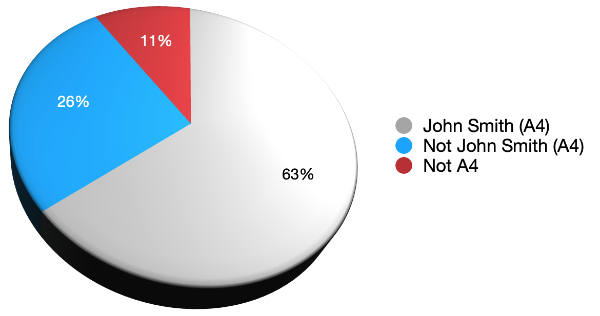
- Properties shown with red numbers are not covered by Article 4(2) but are still classed as included within the conservation area. (Blocks of flats are not covered and are shown in orange)
- Properties shown in yellow are are included in the Article 4(2) and are *”typical John Smith design” (1910 – c. 1926)
- Properties shown in blue are also included in the Article 4(2) and built in other styles. These include some built during the initial development period (1910 – c. 1926) and some built later.

Please note that this is work in progress, if you spot any errors in classification or have any historical information please let us know.
Original John Smith development: 1911 – 1926
*Typical John Smith style means those properties which were part of John Smith’s original development 1911 to c. 1926, e.g. see here. There are later properties that were built to emulate or “pay tribute” to that style. e.g. 18 Leigh Road (2009) 33 Blenheim Avenue (2000)
Note that not all properties built during the original development were of the “John Smith style.” Most of these were probably designed by other architects (TBC). This includes many of the houses on the west (common) side of Westbourne Crescent.
Later infill development
The majority of houses later than 1930 were built on infill sites, for example 36 -44 Blenheim Avenue were built on the large plot that originally served as John Smith’s yard and offices. Others built on are plots that presumably did not sell during the original development. Some houses were built following WWII due to bomb damage (10 and 32 Oakmount Avenue).

 Portswood Broadway Busgate Latest!